
AquaINFRA News
Satellite Monitoring of Water Quality: What We Can See and What We Miss
May 19th, 2026
From a single image, a satellite can map chlorophyll-a concentrations across an entire sea basin. It can track sediment plumes spreading from river mouths, detect algal blooms forming over hundreds of square kilometres, and measure sea surface temperature with a precision of fractions of a degree. For researchers and water managers who once relied exclusively on boats, sampling bottles, and laboratory analysis, this capability has been transformative.
But satellite remote sensing of water quality is not the complete monitoring solution it is sometimes presented as. It has genuine strengths, well-documented limitations, and a set of practical challenges that determine how useful the data actually are for science and policy. Understanding all three is important for anyone working with aquatic data.
What satellites can measure well
Earth observation satellites carry sensors designed to detect electromagnetic radiation reflected or emitted by the Earth’s surface. For water quality, the most relevant instruments measure in the visible and near-infrared spectrum, where interactions between light and water constituents produce detectable signals.
Chlorophyll-a is the most established satellite-derived water quality parameter. Phytoplankton absorb blue light and reflect green, producing a spectral signature that algorithms can translate into concentration estimates. The Copernicus Sentinel-3 mission, carrying the Ocean and Land Colour Instrument (OLCI), provides global chlorophyll-a maps at 300-metre resolution with near-daily revisit times. For open ocean and large coastal waters, these estimates are reliable enough to track seasonal patterns, detect bloom events, and monitor long-term trends.
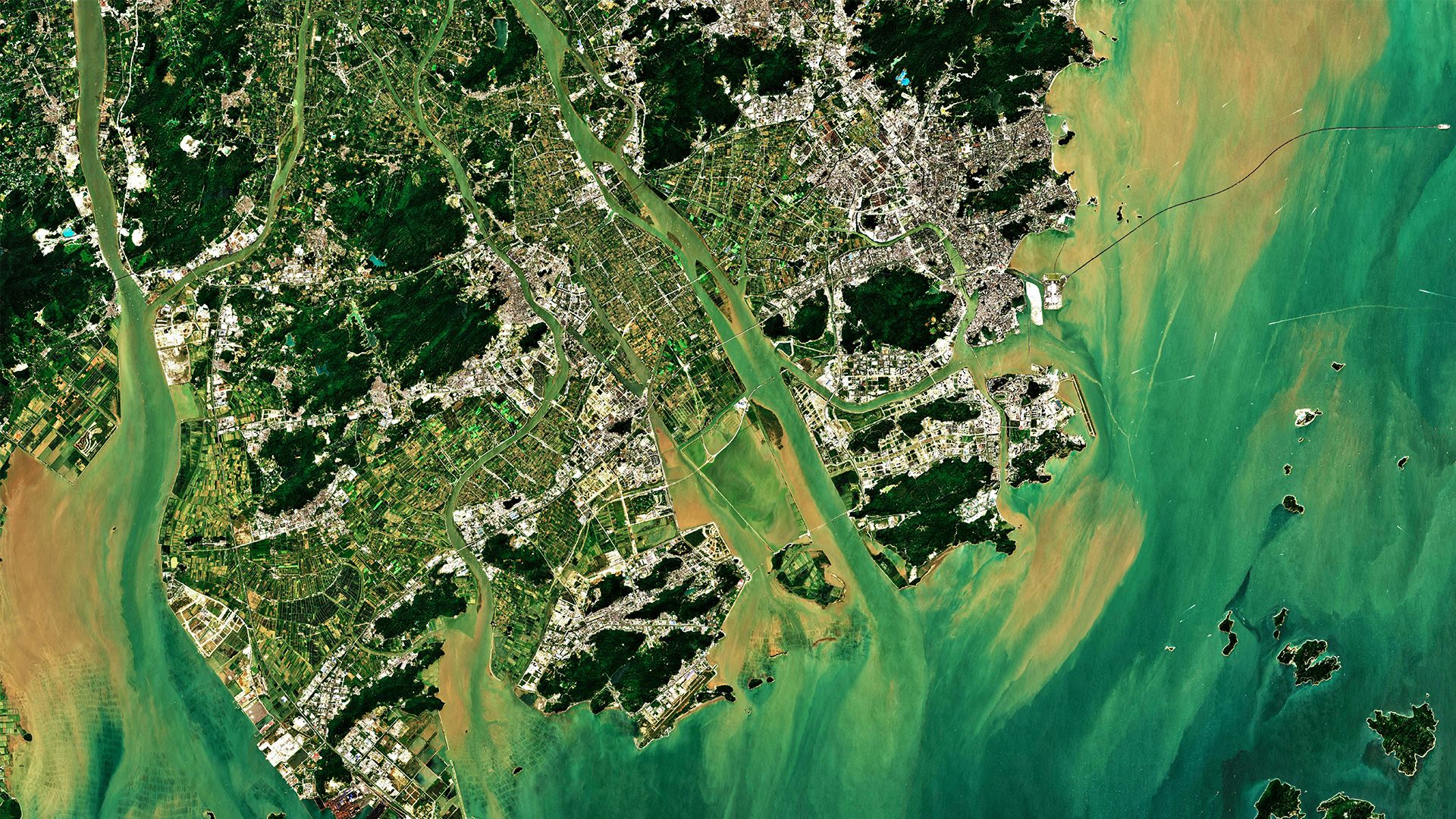
Turbidity and suspended sediment produce strong optical signals that satellites detect effectively. Highly turbid waters scatter more light back towards the sensor, and established algorithms can convert this signal into estimates of total suspended matter. This is particularly useful for tracking sediment transport from rivers into coastal zones, a process that is difficult to monitor comprehensively using in situ measurements alone.
Sea surface temperature (SST) is measured using thermal infrared sensors with high accuracy, typically within 0.3–0.5°C of in situ measurements. SST datasets from satellites now span more than 40 years, providing one of the longest and most spatially complete climate-relevant records available for the ocean.
Coloured dissolved organic matter (CDOM), which absorbs light in the blue part of the spectrum, can also be estimated from satellite data, though with greater uncertainty than chlorophyll-a or turbidity. CDOM is particularly important in northern European waters and boreal lakes, where high concentrations of humic substances affect light penetration and aquatic ecosystems.
Where the limitations begin
For all its power, satellite remote sensing of water quality runs into several fundamental constraints.
Satellites see only the surface. Optical sensors measure light that has interacted with the upper metres of the water column, typically the top one to two optical depths, which in clear ocean water might extend to 20 metres but in turbid coastal or freshwater systems may be less than one metre. Anything below that depth is invisible. Deep chlorophyll maxima, a common feature in stratified lakes and seas where phytoplankton concentrate below the surface mixed layer, are simply not detected. This means satellite-derived chlorophyll-a can systematically underestimate total phytoplankton biomass in stratified water bodies.
Cloud cover blocks the view. Optical satellites cannot see through clouds, and in many parts of Europe, particularly northern and western regions, persistent cloud cover significantly reduces the number of usable images. In the Baltic Sea, for example, cloud-free observations may be available for only 10–30 per cent of overpasses during the growing season. This creates temporal gaps that complicate efforts to track rapidly evolving events such as cyanobacterial blooms, which can form and dissipate within days.
Small water bodies are difficult. Most ocean colour sensors were designed for open ocean and coastal applications, with spatial resolutions of 250–1,000 metres. At these resolutions, many European lakes and rivers are too small to be resolved: the pixel either misses the water body entirely or mixes water and land signals in a single measurement (the “adjacency effect”). The Sentinel-2 Multispectral Instrument, with its 10–20 metre resolution, has opened new possibilities for monitoring smaller lakes, but its spectral bands were not optimised for water quality and its revisit time of five days (with two satellites) limits temporal coverage.
Optically complex waters cause problems. In the open ocean, chlorophyll-a is the dominant optically active constituent, and standard algorithms work well. But in coastal zones and inland waters, often called “optically complex” or Case 2 waters, chlorophyll-a, suspended sediment, and CDOM all contribute to the optical signal simultaneously. Separating their individual contributions is an ongoing algorithmic challenge. Standard ocean colour algorithms can produce large errors when applied to these waters, and region-specific algorithms are often needed.
Not all parameters are accessible. Nutrients such as nitrogen and phosphorus, which are central to eutrophication assessments under the EU Water Framework Directive, do not have direct optical signatures and cannot be measured by satellites. The same applies to most chemical contaminants, dissolved oxygen, and biological indicators such as macroinvertebrate composition. Satellite data can provide indirect proxies, chlorophyll-a as an indicator of nutrient enrichment, for instance, but these relationships are not always straightforward.
The ground-truth requirement
No satellite measurement of water quality stands entirely on its own. Every algorithm that converts a spectral signal into a concentration estimate must be calibrated and validated against in situ measurements, what the remote sensing community calls “ground truth”.
This creates a dependency that is often underappreciated. The quality of satellite-derived water quality data is ultimately limited by the quality and density of the in situ measurements used to develop and validate the algorithms. In regions with dense monitoring networks, such as parts of the North Sea or the Great Lakes, satellite products can be validated thoroughly. In regions with sparse monitoring, many Mediterranean coastal areas, smaller European lakes, rivers, validation data are scarce and the uncertainty of satellite products is correspondingly higher.
The mismatch between what a satellite measures (the average reflectance across a pixel covering hundreds or thousands of square metres, integrated over the upper water column, at the moment of overpass) and what an in situ sensor measures (a point measurement at a specific depth and time) adds further complexity. Reconciling these different measurement scales is a non-trivial technical problem.
The integration imperative
The most productive way forward is not to treat satellite and in situ monitoring as alternatives, but as complementary components of an integrated observation system. Satellites provide spatial coverage and temporal frequency that no network of sampling stations can match. In situ measurements provide depth profiles, chemical parameters, and biological indicators that satellites cannot access, along with the ground truth needed to make satellite data reliable.
Achieving this integration in practice requires shared data infrastructure. Satellite data need to be accessible alongside in situ measurements, in formats that allow joint analysis. Metadata must be sufficient to understand the provenance and limitations of both data types. And analytical tools need to handle the different spatial and temporal scales involved.
European initiatives are working towards this goal. The Copernicus Marine Service and Copernicus Land Monitoring Service provide satellite-derived water quality products for marine and freshwater environments respectively. EMODnet aggregates in situ marine data from national providers. Projects within the EOSC framework are developing platforms where researchers can access and analyse both satellite and in situ data together. But significant gaps remain, particularly in freshwater systems and in the linkage between marine and inland water monitoring.
A technology with real power and real limits
Satellite remote sensing has genuinely expanded what is possible in water quality monitoring. The ability to observe entire sea basins and lake districts simultaneously, repeatedly, and over decades is a capability that did not exist a generation ago. For parameters such as chlorophyll-a, turbidity, and surface temperature in open waters, satellite data are now indispensable.
But the technology is not a substitute for comprehensive monitoring. It cannot see below the surface, cannot measure most chemical and biological parameters, struggles with small and optically complex water bodies, and depends on in situ measurements for its own reliability. Treating satellite data as a complete picture of water quality, rather than as one powerful but partial view, risks overlooking exactly the information that water managers and policymakers need most.
The challenge for the aquatic science community is to build monitoring systems that use each technology for what it does best, connected by data infrastructure that makes integration practical rather than aspirational.