
AquaINFRA News
From River Source to Open Sea: Why Europe's Water Research Needs to Break Down Its Walls
March 19th, 2026
Here is a question that sounds simple but turns out to be remarkably difficult to answer: if a farmer in the Daugava River basin in Latvia changes how they manage nutrient runoff from their land, what difference does it make to the water quality of the Gulf of Riga?
The river is 1,020 kilometres long. It crosses five countries. The nutrient travels through forests and wetlands, past cities and industrial sites, through tributaries and reservoirs, before reaching the coast. Along the way, it is measured (or not) by different national agencies using different methods, stored in different databases, and governed by different regulations. When it enters the marine environment, it falls under a completely different policy framework, monitored by a different set of institutions using different indicators.
The water does not know any of this. It just flows.
This disconnect -- between the continuous reality of the water cycle and the fragmented way we study and manage it -- is one of the most persistent obstacles to effective environmental policy in Europe. AquaINFRA has spent three years confronting it, and the results from four regional case studies across the Baltic, North Sea, Mediterranean, and at the pan-European scale are beginning to show what an integrated, source-to-sea approach looks like in practice.
Two Worlds, One Water Cycle
European water governance is built around a structural division. The Water Framework Directive (WFD), adopted in 2000, governs rivers, lakes, transitional waters, and groundwater. It requires Member States to achieve good ecological status for their water bodies and organises management around River Basin Districts. The Marine Strategy Framework Directive (MSFD), adopted in 2008, governs marine waters. It requires Good Environmental Status across Europe's marine regions and organises assessment around regional sea conventions -- HELCOM for the Baltic, OSPAR for the North-East Atlantic, the Barcelona Convention for the Mediterranean.
These two frameworks were designed to be complementary. In practice, they operate largely in parallel. Different government departments implement them. Different scientific communities generate the evidence for them. Different data systems support them. Even within the European Commission, freshwater and marine policy have historically been managed through separate structures within DG Environment, and marine economic policy through DG MARE.
The data landscape mirrors this separation. Freshwater monitoring data is collected by national environment agencies and hydrological services, typically stored in national databases with national access policies. Marine data is managed through European-level services: EMODnet (the European Marine Observation and Data Network), the Copernicus Marine Service, and the databases of regional sea conventions. Biodiversity records sit in GBIF. Satellite observations are processed by Copernicus. Socioeconomic data on the costs and effectiveness of environmental measures is scattered across government departments and international organisations.
A researcher who wants to answer a question that spans the freshwater-marine boundary -- How do agricultural pressures in a river catchment affect eutrophication in the receiving coastal sea? Does river restoration upstream improve marine biodiversity downstream? -- faces a practical obstacle before the science even begins: finding, accessing, and combining data from fundamentally different systems.
What AquaINFRA Found
AquaINFRA was designed to bridge this divide. Its platform connects over 15 European data sources spanning both freshwater and marine domains through a single Data Discovery and Access Service (DDAS). Its Virtual Research Environment (VRE), built on the Galaxy platform, provides the analytical tools to combine and process data from across this spectrum. Its case studies were deliberately chosen to test source-to-sea questions in different European sea regions.
The results are instructive -- not because they discovered that the freshwater-marine connection exists (everyone knows it does), but because they demonstrated that integrated analysis is technically feasible when the right infrastructure is in place.
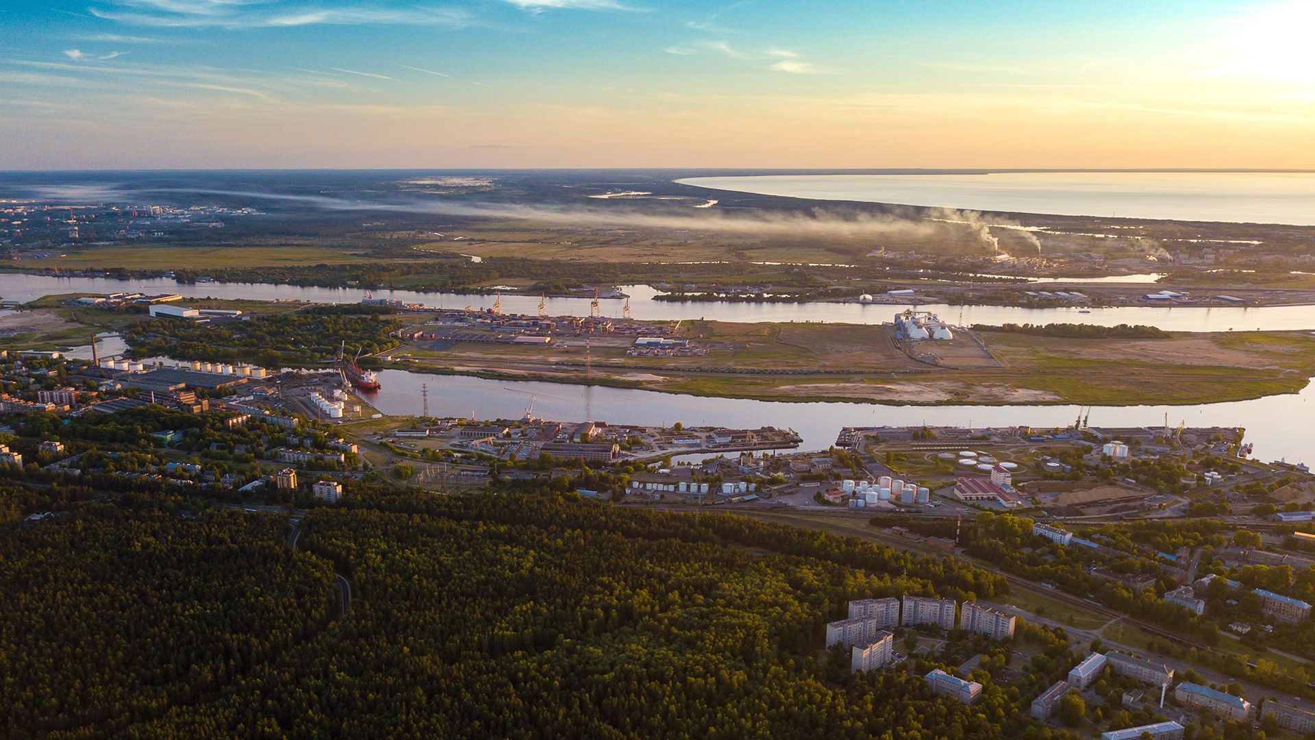
The Baltic: Tracing Change Over Three Decades
In the Gulf of Riga, AquaINFRA researchers combined Latvian national Secchi depth monitoring data with HELCOM spatial assessment units to detect long-term trends in water clarity. The analysis, conducted through a published Galaxy workflow using the Mann-Kendall statistical trend test, revealed a statistically significant decline in Secchi depth in the eastern coastal region of the Gulf of Riga over the past 30 years. The water is getting darker.
This brownification -- likely linked to changes in dissolved organic matter inputs from the Daugava River's 87,900 km2 catchment, where 67% of the land is forested and 26% is agricultural -- is a source-to-sea phenomenon. It originates on land, travels through the river system, and manifests in the coastal marine environment. Understanding it requires data from both sides of the freshwater-marine boundary.
But the case study went further. A separate analysis applied the DPSIR framework (Drivers-Pressures-States-Impacts-Response) to assess the effectiveness of environmental measures implemented under both the Water Framework Directive and the HELCOM Baltic Sea Action Plan. This meant connecting three types of data that rarely sit in the same database: socioeconomic information about what management actions were taken and at what cost (Response), monitoring data on nutrient loads entering the Baltic from rivers (Pressure), and marine eutrophication status indicators (State).
The result is a method for assessing whether the actions countries take in their river basins are actually improving the marine environment they are trying to protect. That is the fundamental policy question that the source-to-sea approach is designed to answer.
Critically, the Gulf of Riga workflow proved transferable. It was successfully applied to the Bothnian Bay -- a different Baltic sub-basin, with different data providers and different environmental conditions -- without rebuilding the analysis from scratch. This is what reproducible, FAIR-compliant infrastructure enables: a method that works in Latvia also works in Finland.
The Mediterranean: Coupling Models from Catchment to Coast
The Mediterranean case study took a different approach to the same fundamental challenge. In Catalonia, researchers coupled three models to simulate the full source-to-sea water cycle:
SWAT+ models rainfall, runoff, and nutrient transport across the Tordera river catchment (898 km2) and Maresme county (398 km2)
MITgcm models ocean circulation, temperature, and salinity in the Catalan Sea, including the effects of river discharge on coastal waters
Automated Copernicus data retrieval provides weather forcing and marine boundary conditions
The result is a fully operational Galaxy workflow that can trace how conditions on land -- drought, flooding, agricultural practices, land use changes -- translate into impacts in the coastal sea, including pollutant transport and harmful algal bloom risk. The workflow is published and reproducible.
In Malta, where the entire island archipelago covers just 246 km2 and 51.3% of land is agricultural, a different source-to-sea question was addressed: how sea level rise affects the freshwater lens that provides the island's groundwater. Using the SEAWAT model to couple groundwater flow with marine conditions, researchers demonstrated that the source-to-sea relationship runs in both directions. The sea affects the land as much as the land affects the sea.
The North Sea: Consistent Monitoring Across Borders
In the Elbe estuary, German Bight, and Wadden Sea -- and separately in the Oslofjord and Glomma River system in Norway -- the North Sea case study focused on creating consistent water quality observations across the zone where rivers meet the sea. Using Sentinel-3 satellite data processed with optical water type-specific and neural network-based algorithms, the team produced a standardised water quality dataset spanning the entire North Sea and Baltic region for June through September 2023.
This is significant because the river-coast transition zone is precisely where standard satellite processing algorithms fail. The optically complex mixture of phytoplankton, suspended sediment, and dissolved organic matter in estuarine and coastal waters confounds methods designed for the simpler conditions of the open ocean. By developing processing approaches suited to these conditions, and applying them consistently across national maritime boundaries, the case study showed that comparable monitoring is achievable across the jurisdictions that share the North Sea.
Pan-European: Mapping Connectivity at Continental Scale
The pan-European case study operated at a different scale entirely. Using the Hydrography90m dataset -- a globally seamless hydrographic network at approximately 90-metre resolution comprising 1.6 million drainage basins and 726 million unique stream segments -- researchers analysed freshwater biodiversity patterns and riverine connectivity across 378 European catchments.
This work addressed questions about how river barriers (dams, weirs, culverts) fragment aquatic habitats and affect fish species diversity and migration, combining hydrographic data with GBIF species occurrence records and a European barrier atlas. Two new R software packages were developed and published to support this work: specleanr for automated quality control of species distribution data, and fwtraits for standardised access to freshwater ecological trait data.
While this case study focused on the freshwater domain, its relevance to source-to-sea thinking is clear. River connectivity determines how nutrients, sediments, and organisms move through catchments toward the coast. A fragmented river system does not just affect freshwater biodiversity; it changes what reaches the sea.
The Infrastructure That Makes It Possible
Across all four case studies, a common pattern emerges. The science depends on infrastructure that can:
1. Discover data across domains: The DDAS integrates freshwater and marine data sources -- from CUAHSI and HydroSHEDS to EDITO and HELCOM -- into a single search interface using a catchment-based spatial framework that follows the natural flow of water, not administrative boundaries.
2. Connect data across standards: OGC API standards, INSPIRE compliance, and shared spatial reference units (HELCOM sub-basins, Hydrography90m catchments, EEA reference grids) provide the common language that allows data from different providers to be combined in the same analysis.
3. Enable reproducible, transferable analysis: Galaxy workflows can be published, shared, verified, and reused. A workflow that detects trends in the Gulf of Riga works in the Bothnian Bay. A coupled source-to-sea model for Catalonia can be adapted for other Mediterranean catchments.
4. Preserve results for reuse: Integration with EUDAT B2SHARE and Zenodo means that datasets and workflows are published with persistent identifiers and open licences, ensuring they remain accessible regardless of the fate of any individual project.
This is not infrastructure that any single case study team could have built on its own. It is the shared platform that AquaINFRA provides -- and the reason why source-to-sea research at this scale is now feasible in a way it was not three years ago.
What Needs to Change
The source-to-sea approach is not new as a concept. The EU Mission "Restore our Ocean and Waters by 2030" explicitly calls for it. HELCOM's Baltic Sea Action Plan implicitly requires it. The logic is straightforward: you cannot restore healthy seas without managing the rivers that feed them, and you cannot manage rivers effectively without understanding where they end up.
What has been missing is the practical infrastructure to do it: the data connections, the analytical tools, the shared standards, and the reproducible methods that allow researchers and policymakers to work across the freshwater-marine boundary as easily as water crosses it.
AquaINFRA has demonstrated that this infrastructure can be built and that it works. The question now is whether it will be sustained -- through the EOSC Federation, through institutional commitments, through whatever combination of mechanisms proves viable -- and whether the lessons from four regional case studies will influence how European water governance evolves.
The Water Framework Directive and the Marine Strategy Framework Directive are both due for review and potential revision. River Basin Management Plans and Marine Strategy Programmes of Measures continue to be developed in parallel processes, by parallel institutions, using parallel data systems. Every round of reporting is an opportunity to bring them closer together.
The water does not respect our organisational boundaries. Our research infrastructure, at least, no longer has to.